Stanford
UniversitY
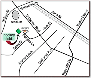
From 101 take the Embarcadero Road exit and go west on Embarcadero
for about 2 miles. It hits El Camino, take a left on El Camino.
Go to the second light, Serra, and take a right. At the stop
sign turn right onto Pampas Lane. Drive straight ahead hich
leads to a small parking area. Park your car and walk
between the fenced areas. The turf field is to the left.
From
El Camino Real North take a left at Serra and then a right
onto Pampas.

Yahoo
Interactive Map - Stanford University
|
Maxwell Family
Field, UC Berkeley
1st Option:From 101 North, take Dumbarton
Bridge to 880 north. Just past Oakland follow exit to Highway
24 towards Concorde/Walnut Creek. Take the Exit at Claremont
Ave. Go left towards the hills. Turn left on College Ave then
right on Durant. At the T junction go left. Drive past the
International house and the football stadium. Maxwell Field
is on the right. Maxwell Field is at the intersection of
Gayley Road & Stadium Rim Way. It is located between
the California Memorial Stadium and the Hearst Greek Theatre,
near the Haas School of Business.
Second Option:101 North to the Bay Bridge.
Go over the bridge to Highway 24 towards Concorde/Walnut Creek.
Exit at Claremont Ave. Go left towards the hills. Turn left
on College Ave then right on Durant. At the T junction go
left. Drive past the International house and the football
stadium. Maxwell Field is on the right. Maxwell Field
is at the intersection of Gayley Road & Stadium Rim Way.
It is located between the California Memorial Stadium and
the Hearst Greek Theatre, near the Haas School of Business.
Yahoo
Interactive Map - UC Berkeley
|
Berkeley High School
2246 Milvia Street, Berkeley, CA 94704
Directions from SF: (Driving time can take up to 45 minutes during Rush Hour- suggest taking BART)
Cross Bay Bridge & get in the second right lane, following signs for Route 24E towards Walnut Creek. Exit at 51 Street/Martin Luther King Blvd. Take a left turn at end of ramp onto Martin Luther King Jr Way (don't go to 51 street). Follow MLK for about 2.5 miles (past Ashby BART), past Ashby avenue, past Dwight Way. Take a right onto Channing Way. Field is on left.
Alternate Directions From SF: (Driving time may take one hour during Rush Hour- suggest taking BART)
101 North to Bay Bridge (80E) Once over the bridge, follow signs to stay on Hwy 80 From Hwy 80, get off at University Ave. Take University Ave. east towards Berkeley. Turn Right onto Martin Luther King (go approx. 0.5 mi. & you'll see the field on your left) At second light, turn Left onto Channing Way. Turf Field is on Left.
BART (5-6 block walk to Berkeley High from Downtown Berkeley BART Station)
Take the Richmond line to the Downtown Berkeley station (next station after Ashby Station). Walk up to the street (you'll be on Shattuck Ave.). Walk south on Shattuck past Allston Way, Kittredge St, & Durant St. Make next right onto Durant Ave. Make left onto Milvia St. You'll see Berkeley High School on your right. When you get to the end of the school building, turn right & walk past the baseball field (on left), through the portable campus trailer buildings, & through the parking lot to the field.
Yahoo Interactive Map - Berkeley High School
BHS Campus Map
|
Chabot College,
Hayward
From 101, take 92 East:From 880, take 92 West:
Exit at Hesperian Blvd. Go North approximately 4 blocks Turn
left (at the Theatres-past subway) into the parking lot
Drive to the back righthand corner of the lot. Follow the
road along the tennis courts Park in the back lot Wed Practices
are in the football stadium. Sat/Sun practices are on the
soccer field.
Map
of Chabot College
|

